About
Background
Artificial satellites are greatly affected by the space plasma environment. The effects are classified according to the energy range of the responsible plasma particles as follows.
・Energetic particles (~GeV), such as solar energetic particles and galactic cosmic rays, can cause malfunctions of computers and memories onboard satellites.
・High-energy electrons (several hundred keV to MeV) in the radiation belt penetrate the wall of satellite structure and accumulate in components inside the satellite. This phenomenon is called the “Internal Charging.” When the accumulated charge is discharged, it can lead to malfunctions or failures of the onboard equipment.
・In addition, plasmas with energies ranging from keV to tens of keV in the magnetosphere can cause the “Surface Charging.” When a magnetospheric disturbance called “substorm” occurs, auroras become visible on the ground, while in the space, plasmas flow into the GEO region from the night-side magnetosphere and electric charge accumulates on the satellite's surface. This phenome called “Surface Charing.” The plasmas also flow into the polar region along the Earth's magnetic field lines, causing the surface charging of polar-orbiting satellites. When the accumulated charge is discharged, it can lead to damage to the satellites.
The space environment significantly changes in space and time depending on the solar wind–magnetosphere interactions. Therefore, the space plasma environment is different depending on the satellite location. In addition, how deeply a satellite is charged in a certain plasma environment depends on the design and material of the satellite itself. Therefore, it is difficult to assess the charging risk of a satellite from the general space weather information. So, for the safety and stability of satellite operation, we are promoting “SECURES (Space Environment Customized Risk Estimation for Satellites),”[1] an initiative to estimate the charging risk of individual satellites by combining space environment models and spacecraft charging models. This website provides information on surface charging risks in the GEO region as the part of SECURES.
Models and Data
Plasma environment data are calculated by a real-time magnetosphere simulation[2] driven by the real-time solar wind data acquired by the DSCOVR spacecraft. The real-time magnetosphere simulation is running on a High-Performance Computing System at National Institute of Information and Communications Technology (NICT).
A virtual GEO satellite (assumed to be a 3-axis commercial satellite) is predesigned[3] as the model satellite using Spacecraft Plasma Interaction Software (SPIS).
By using the plasma environment data at the model satellite position extracted from the simulation, the maximum surface potential, frame potential, and differential potential (the difference between the maximum surface potential and frame potential) of the model satellite for that environment are calculated.
About Images
Plasma pressure distribution in the near-earth space calculated by the magnetosphere simulation is shown.
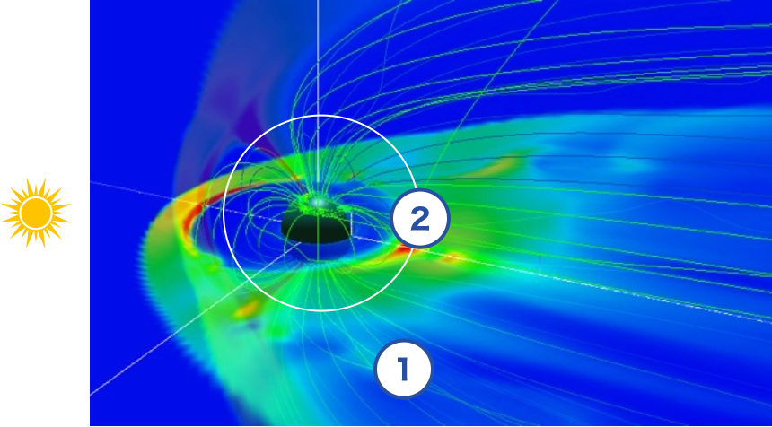
・Magnetospheric equatorial plane viewed from the north, with the left side toward the Sun.

・Geostationary orbital sphere (6.6 earth radius, altitude approx. 36,000 km) shown in the Mercator projection.
・The Japanese sector is longitude 135°, to which the environment data moves with the time (with the Earth’s rotation).
・A small circle indicates the eclipse area.
・High plasma pressure regions seen in the dayside high latitudes are formed by the solar wind-magnetosphere interaction. These regions are outside the scope of the risk estimation.


References
[1] T. Nagatsuma, A. Nakamizo, Y. Kubota, M. Nakamura, K. Koga, Y. Miyoshi, and H. Matsumoto, “Development of space environment customized risk estimation for satellites (SECURES).” Earth Planets Space, Vol. 73, No. 26, 2021, https://doi.org/10.1186/s40623-021-01355-x.
[2] Nakamizo, A., and Kubota, Y., “Research and Development of a Global Magnetosphere MHD Simulation,” NICT Research Report, Vol. 67, No. 1, pp. 97-104, 2021 (in Japanese).
[3] M. Nakamura, A. Yamamoto, A. Nakamizo, and T. Nagatsuma, “Spacecraft surface charging estimation method around the geosynchronous altitude,” in Proc. the 16th Spacecraft Charging Technology Conf., 2022.
Acknowledgment
The fundamental research related to this website was conducted by Osaka Prefecture University (now Osaka Metropolitan University), Japan Aerospace Exploration Agency (JAXA), and National Institute of Information and Communications Technology (NICT) with the support of MEXT/JSPS KAKENHI Grant Numbers JP15H05813 and JP15H05815, Project for Solar–Terrestrial Environment Prediction (PSTEP).
This website was developed with the support of “Promotion of observation and analysis of radio wave propagation,” commissioned by the Ministry of Internal Affairs and Communications, Japan.
The real-time solar wind data is provided by National Oceanic and Atmospheric Administration (NOAA) Space Weather Prediction Center (SWPC).
Site Policy
Please note that the plasma environment data provided on this website is simulated by a magnetosphere model, and the satellite potentials are estimates based on a combination of the plasma environment data and a model satellite. The information on this website is provided by NICT. SECURES and NICT has no responsibility for any damages or disadvantage caused by using any information provided by this website even regardless of any reasons. The information provided on this website may be suspended or discontinued, in whole or in part, temporarily or permanently, or the content, attributes (including format), etc. may be changed without prior notice.